They’re called smartphones for good reason (First of two parts)
This item appears on page 50 of the February 2018 issue.

They’re called smartphones for good reason
(First of two parts)
I prefer to use my bike to get around my hometown of Santa Barbara, so I see firsthand the number-one distraction of modern life: the smartphone. And it’s not just drivers who are distracted; cyclists and pedestrians are guilty of it too.
On the other hand, the device has been positively life-transforming. For travelers, the smartphone is like a digital Swiss Army knife — capable of meeting so many of our “survival” needs, yet it fits in a pocket.
I use an iPhone 6, so I’m going to reference its functionality, but Android phones are similarly capable, if not more so.
The basics
We get so caught up in texting, web browsing, emailing and occasionally talking on our phones that we sometimes overlook the obvious. Flick up from the bottom of any screen to reveal shortcuts to the basics: flashlight, clock/travel alarm, calculator and camera. [See screenshot pictured to the right.]
There was a time, say, 10 years ago, when reading the menu in the dim light of a restaurant or setting your bedside alarm or calculating currency-exchange rates or taking a picture required a separate device. Some travelers still pack travel alarms and mini-flashlights, but I urge them to travel as light as possible, using their phone’s utilities instead.
Camera
I try to minimize the paperwork I travel with nowadays. I use the phone’s camera to record vital travel documents like my passport, driver’s license and credit cards.
Snap a picture to remember your parking spot or the condition of your rental car before you drive off, or take a screenshot of something important on your phone by pressing and holding down your home button and then your power button and then quickly releasing both.
Did you know the camera has a magnifier feature? Go to Settings/General/Accessibility/Magnifier and tap “On.” Clicking your home button three times in quick succession activates the magnifier, complete with a slider bar for zooming in and a lightning bolt icon for light. Very handy for reading fine print!
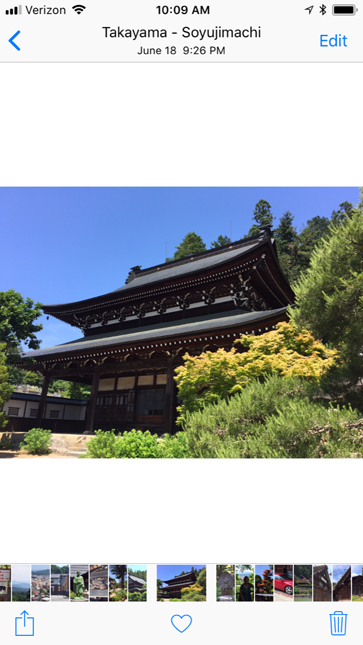
I find the built-in Geotagging feature of the camera very handy for verifying locations of photos. The feature is enabled by default, and it approximates your location using GPS, Bluetooth, crowd-sourced Wi-Fi hotspots and cell tower locations.
If you’re creeped out by the notion of creating an electronic trail, then you can disable it through Settings/Privacy/Location Services.
On a recent trip to Japan, it proved invaluable in identifying each shrine and temple. For example, for one picture I shot, Geotagging provided the location “Takayama - Soyujimachi” at the top of the image as well as the date, “June 18.” (Oddly, the time reflects your home time zone.)
Navigation via Google Maps
I rely on Google Maps when I travel, but I take along old-fashioned printed maps too. While I use Google Maps to navigate from point A to B, I use printed maps to put places of interest (like parks, museums and historical sites) in the larger context of the city or region.
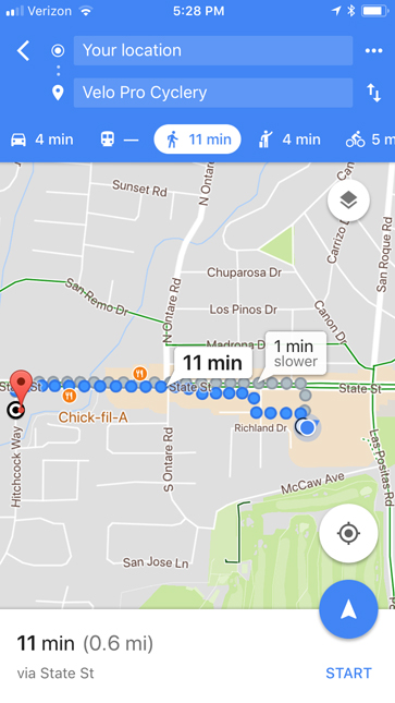
Google Maps is great for public transportation options, revealing bus, subway and train routes and stops.
Locating places to eat is important while traveling, and Google Maps provides restaurant locations around your chosen destination, with ratings a click away, for better or worse.
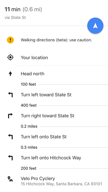
Even though I’ve used Google Maps a lot, I can still get befuddled following its walking directions. For example, consider these directions: “Head north 100 feet. Turn left toward State St 400 feet. Turn right toward State St 0.2 miles….” For starters, which way is north?
If a compass direction is unclear, I either guess and walk a minute in one direction and then check my progress on the map or I open up the Compass feature in my Extras folder and follow the arrow. Neither method is foolproof, as I found out in Mexico City recently when I couldn’t figure out how to follow the prescribed walking route back to my hotel from Chapultepec Castle.
Facing a pretzel of busy roads converging on the east side of the park, I had to try several walking routes because Google Maps seemed to guide me onto roadways without sidewalks.
Next month, I'll continue describing features of smartphones that travelers find invaluable.
Mark Gallo is the owner of CircaTerra Travel Outfitters (Santa Barbara, CA; 805/568-5402, circaterratravel.com), and he can be reached at mgallo@circaterratravel.com.