Picturesque Patagonia – a cruise along the southern coast of Chile
This article appears on page 20 of the April 2018 issue.
I had the good fortune in October-November 2017 to join an expedition to Patagonia conducted by Lindblad Expeditions-National Geographic. Our trip began in Santiago, Chile, and I spent one day there before the tour started in order to get acclimated after flying in from San Francisco, California.
There were 75 of us on the first portion of the trip, which consisted of two days in Santiago and three days in inland Patagonia. The group would then join an additional 20 passengers when we all boarded National Geographic’s Orion for seven days of cruising the waters along the coast of southern Chile.
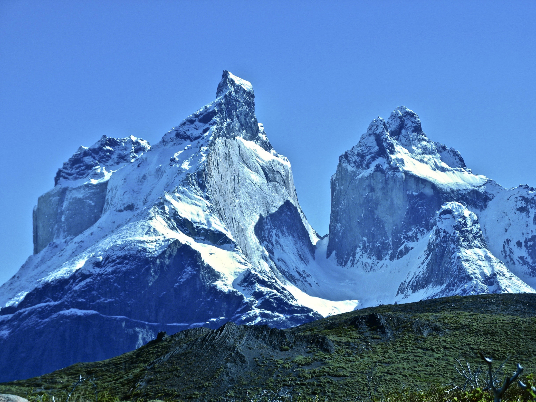
Torres del Paine
After our two days in Santiago, spent sightseeing in this city of 7 million, we flew to Punta Arenas and continued by bus to Puerto Natales, where we spent the night in the lovely Singular Patagonia hotel.
The next morning we moved on to our hotel in Torres del Paine (“Blue Towers”) National Park, in the heart of Patagonia. The site of the Tierra Patagonia Hotel was fabulous, located on the shore of a lake with the eponymous three granite pinnacles (the “towers”) rising into the sky on the other side.
Patagonia is huge — about 400,000 square miles of mountains, rivers, glaciers and lakes shared by Chile and Argentina — and we were going to see just a small part of this wonderland.
The area had experienced record rainfall over the previous six weeks, resulting in some of the roads having been washed out and causing many of the lakes and rivers to overflow. Everything glistened with water drops.
Nevertheless, after lunch, our group of 75 hardy travelers split into smaller groups to explore the area. I chose to go to the Blue Lagoon, which wasn’t so blue due to the runoff from all the rain, but we were so lucky with the weather. The skies were blue for the first time in weeks.
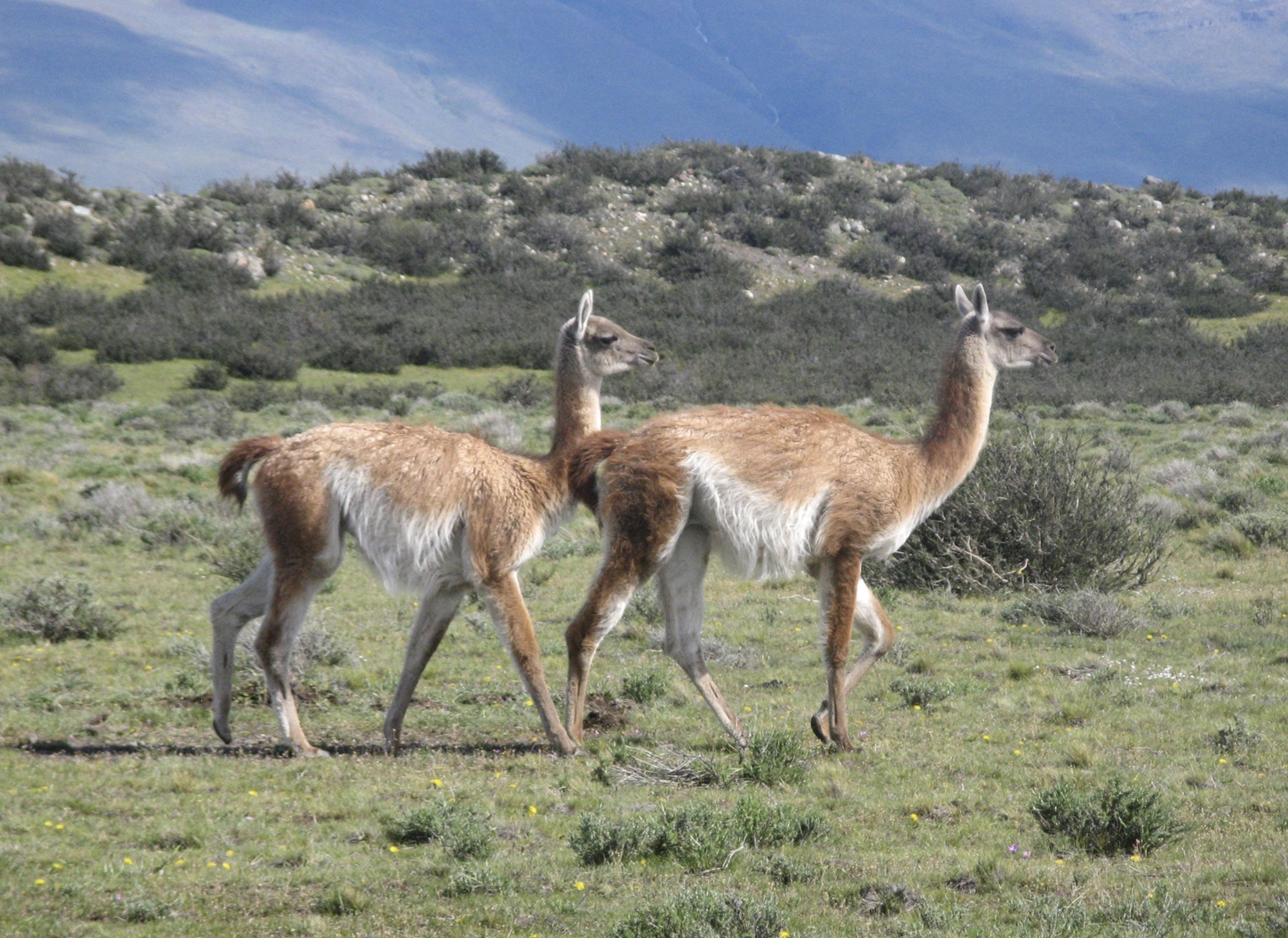
On our drive to the lagoon we saw hundreds of guanacos, relatives of llamas, alpacas and vicuñas, all members of the camelid family. They gather in herds, with several of their members standing guard on the periphery of the group as sentinels, watching for one of their only predators, the puma.
We didn’t see any pumas, but we did see a number of condors, gray foxes, rheas (a flightless bird related to ostriches and emus) and one skunk.
After returning to the hotel, I sat in the lobby looking through the 15-foot-high windows at the snowcapped mountains and their reflection in the lake. I also sneaked a look at the dinner menu, which offered a choice of conger eel, llama or lamb chops. (What would you choose?)
Dramatic landscapes
The next morning, I went on a long, tough hike past waterfalls and surging rivers. The paths were rocky, except where they were muddy or covered with water due to the recent heavy rains. There was a lot of going up and down, but it was worth every drop of perspiration because of the fabulous scenery — snow-covered peaks, blue skies, green lowlands and herds of guanaco.
The next day was another long one, an 11-hour tour that included hiking, sightseeing and a 3-hour cruise on Lake Grey, where we got very close to Grey Glacier and witnessed some calving. The lake had many icebergs of all shapes and sizes. It was very much like the landscape in Antarctica or Alaska’s Glacier Bay but on a smaller scale.
We saw some of the most spectacular scenery I’ve ever witnessed. The mountains there are young in geological terms, so they are very craggy, pointed, spindly and rugged. The striations of rock, where pressure over millennia has been at work, are twisted and folded.
The skies were blue and the temperature about 55°-65°F — a Chamber of Commerce day!
Getting on board
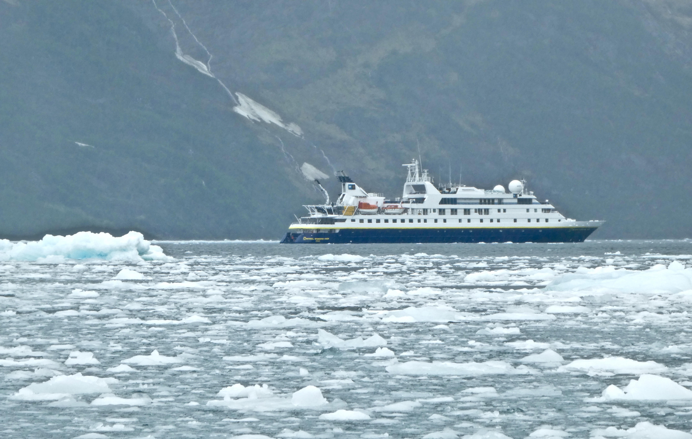
We left the next day by bus for Puerto Natales, where we met the additional 20 guests who had elected to take only the nautical portion of the trip. Together, we boarded the Orion, which holds a maximum of 102 passengers.
I had been on this ship before, and it had changed. The bathrooms had been upgraded (all marble now), and the public areas were redone to great advantage. I had the same single cabin (there are only five single cabins on board) that I had on my last trip and immediately felt at home.
The next morning we had brief lectures on how to board a kayak and a Zodiac (an inflated rubber boat powered by an outboard motor that can hold 10 to 12 passengers). We certainly needed the lectures because that afternoon we boarded Zodiacs to explore the fjord our ship had entered in the morning.
Our good luck with the weather ran out on this outing. It was pouring, with a temperature of about 50 degrees, but we had been warned before the trip, so all of us were wearing rainproof parkas and pants, knee-high rubber boots and warm gloves.
Many in our group were avid photographers, and they had a difficult time keeping their very long lenses dry.
Into the ice
The fjord was lined on both sides by steep cliffs, mostly covered with snow except near the bottom of the slopes. Because of the low clouds, we couldn’t see the tops of the mountains. Streams and waterfalls were threading down the mountainsides, and a number of glaciers ran right down to the water.
We saw lots of glaciers calving as we motored through the fjord — loud, thunderous “booms” followed by, if you looked quickly enough, the sight of ice and snow crashing off the face of the glacier into the sea.
The water was filled with different kinds of ice. “Brash” is an accumulation of small pieces of ice, measuring less than two meters across. “Bergy bits” are defined as pieces of ice standing 3 to 5 meters above the water; “growlers” are fragments slightly smaller than those, and icebergs rise 5 or more meters above the water. (And, as you know, what you see above the water is only 10%-15% of the whole ice formation.)
Our Zodiac skirted the bigger bergy bits but was able to roll over the brash.
We were out on the water for only about 90 minutes, long enough to get our fill of photos… and to get really cold (and, for those whose clothes were not as “waterproof” as advertised, really damp). We were glad to get back to the ship for hot chocolate and a hot shower, but the experience was well worth the chill.
When we were all on board and the Zodiacs had been stowed, we cruised back along the fjord toward the Pacific, following a generally southern path through the Straits of Magellan for the balance of our cruise. The coast of Chile is furrowed with fjords, and we would be exploring a number of them on this trip.
Zodiac excursions
I have one word to say about the food on our cruise: excellent! The beautiful preparation and display of the breakfast and luncheon buffets included a variety of hot and cold choices. For dinner, there was a choice of three appetizers, three entrées and several desserts. Wine, beer and other beverages were included at all meals and throughout the day and evening.
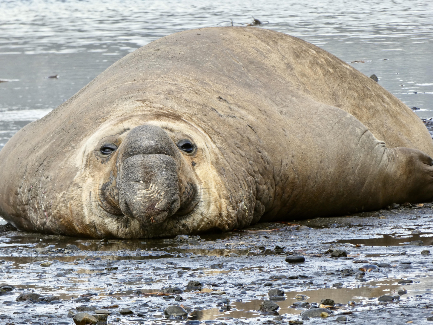
On our journey south, we anchored off the Karukinka Reserve, a privately owned reserve. We Zodiacked to shore, where we were greeted by three elephant seals, each weighing 2,500 to 3,000 pounds, according to our naturalist guide.
“Greeted” might be an overstatement, as they lay on the rocky beach and paid us no attention at all. We did get a slightly more robust ‘Hello’ from two nearby baby elephant seals, if you can call a 300-pounder a “baby.”
The sky was deep blue, the water was jade green flecked with white bergy bits, and the rocky sides of the fjord were snowy white. Perfect!
Life on board
We were all dressed in rain pants, waterproof jackets, hoods, gloves, life vests and knee-high rubber boots, just in case it rained, but it didn’t… not that day or for the rest of the trip.
We had a “wet” landing, meaning that we had to step out of the Zodiac and wade through foot-high water to the beach. One of the passengers on our Zodiac had forgotten her rubber boots, so one of the staff carried her to shore.
The overall goal of the morning was to hike to a waterfall about a mile away, but that was easier said than done. We started out over the gravelly beach, then climbed over a couple hundred yards of sun-bleached driftwood that had been carried to the shore by tidal action, continuing through thickets of thorny calafate bushes on paths made by the local guanacos and through a beech-tree forest where fallen trees and limbs were strewn over every square foot (all the while jumping over or wading through small steams) until, finally, we arrived at the foot of the waterfall.
But to really get a good look, we had to climb up a rocky, slippery hill. Man, if I had known I had to do all that work, I wouldn’t have gone to the ship’s fitness center that morning!
During the night, the ship worked its way south to the Beagle Channel, named, of course, for the ship carrying Darwin when it came through in about 1830. We sailed along Tierra del Fuego, an archipelago that is home to Ushuaia, the world’s southernmost city, at the tip of South America.
Early every evening, the ship’s staff gave a recap of the day’s activities and shared what to look forward to the next day. One of the best things about traveling with National Geographic was the staff. They all seemed to have PhDs in ichthyology, ornithology, oceanography and many other “ologies.” They were very enthusiastic in their presentations and were most happy to sit down with the passengers, answer questions and engage in conversation about what we had seen.
I have noted that many of the passengers were serious photographers. The ship’s staff included two National Geographic photographers, who were there to assist passengers with their photo-taking and to answer questions about their camera equipment. I had a new camera, and its mysteries were explained to me in just a 30-minute sit-down with one of the NG photographers.
There was also a closet on board full of new photographic equipment that could be taken by passengers for a “test drive.” National Geographic is very interested in promoting photography.
Nearing the end
We ultimately found ourselves anchored off Cape Horn, at the bottom of South America. Those of you who were devotees of seafaring novels when you were kids (and maybe even today) know about the dangerous Cape Horn, where scores of ships and hundreds of sailors were lost over the centuries in terrible storms. Well, you wouldn’t believe those stories if you had been sitting with me on the deck of the Orion, looking at that fearsome pile of rock on such a beautiful day, with calm seas and no clouds.
Near our last day of the cruise, we left Chilean waters and entered Argentinean waters for the first time. We anchored off Staten Island (yes, they have a Staten Island there, too), where some of the passengers went ashore in Zodiacs for a climb up to the lighthouse there.
On our last day on the ship, we anchored in Bahia Capitán Cánepa, on the southern coast of Staten Island, under blue skies and surrounded by dark-green water in 65-degree weather. The Argentinean pilot now who had come on board told me they have good weather like that only 20 to 30 days in a year. Our good-weather luck had held!
We had two Zodiac excursions available on our final day. The first involved heading ashore for a hike to see some rockhopper penguins. These little critters don’t look like typical “tuxedo” penguins; they have stringy yellow feathers poking out of their heads.
They are called rockhoppers because they live on rocky slopes and get around by… hopping from rock to rock. Who knew?!
The second Zodiac activity was a 90-minute exploration of the bay and surrounding areas. We were encircled by rocky hills rising perhaps 1,500 feet high. The lower slopes were covered with low vegetation and shrubs, and the upper slopes were solid, craggy granite.
Mother Nature must have really cranked up the pressure when she created these hills. They were twisted, folded over and striated — very impressive.
Our adventure ended the next morning when we docked in Ushuaia, then took a charter flight to Santiago, from where we found our respective ways home.
The trip cost, including a single supplement and internal air flights, was $20,975. It cost an additional $3,900 for round-trip airfare from San Francisco to Santiago.
It took me 36 hours and three flights to get back to San Francisco — a long way but worth every minute of travel to experience this beautiful and pristine part of the world.